On June 25, 2023, the sky had visible shimmery chemical trails. Nothing really unusual, as lately there seem to be ubiquitous trails on any given day. What made this observation different was the day that followed.
June 26, 2023, was a pretty ordinary day. I was testing a new bread recipe, and the bread would be done later that evening. It just so happens that my bread was ready at the same time a strange storm rolled in. I sat on the porch, eating the most delicious bread, while documenting a bizarre storm.
There was a delineating line of air masses moving through. The lighter skies were moving in an air mass coming from the South, yet, the storm depicted on the weather maps, was clearing moving from the West.
Ok, “air masses collide and create thunderstorms, no big whoop”, is what you’re thinking. I thought that too, but I have sat and watched MANY a thunderstorm in my lifetime, and this one was different.
Here is the beginning of the storm: https://rumble.com/v2xebcg-june-26-2023-geoengineered-storm.html
One quick editorial note: in the video I state that one air mass is coming from the East. I misspoke. It’s coming from the West, I’m filming toward the East.
The rain started moving sideways in the upper atmosphere. Again, not super “smoking gun” that it’s geoengineered. It’s difficult to see, as the camera wasn’t picking it up very well.
Sideways rain: https://rumble.com/v2xedzw-sideways-rain.html
As the storm progressed, the air masses that previously collided started moving South to North.
South to North movement: https://rumble.com/v2xefnm-strange-storm-moving-south-to-north.html
After the storm looked like it was wrapping up, there were suddenly no cloud formations, only an oddly colored haze. I know what you’re thinking, “Canadian Wildfires”. Except, we are South of Canada, and the air mass is moving from the South to the North.
Weird haze: https://rumble.com/v2xegg6-weird-haze-after-thunderstorm.html
All in all, it looks like a normal thunderstorm, right? Kinda? Sorta?
Take into account what the radar maps showed:
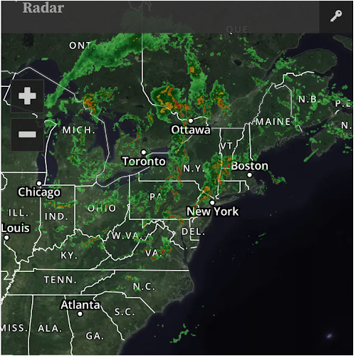
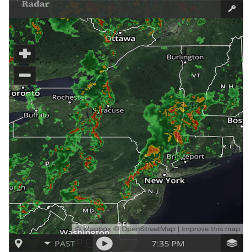
Also, when storms show clear patterns of being manipulated by climate engineering, as documented multiple times on geoengineeringwatch.org, the radar patterns look similar to this vortex of nothingness in the middle.
Perhaps this wasn’t climate engineering, but the observations taken all together raise suspicions. The biggest observation; however, cannot be so easily put into media or written context, and that’s what was felt with my senses before, during, and after the storm.
Biology knows when something’s amiss. We should trust it more, along with the outward observations.
